Montana Hunt 2011
Sunday, Oct 23

Page Five
First posted November 22, 2011 Last edited November 25, 2011
Second Day: David's Meadows
The weather radio had predicted that the weather was going to be rainy and snowy, which dampened our enthusiasm for going out. I was out first, because I knew I had a bit of a walk ahead of me, and I wanted to be at the meadows I could see on the map at daylight. Craig and Ted thought I was nuts going out so early; maybe I walk slower than they do. They must have left shortly after I did. The rest slept in.
I drove Bill's Bronco to the same place as yesterday and headed out toward the saddle in the dark. I had noticed that the map on my GPS was not quite the same as my printed map: there was a path heading out the way the four hunters I had seen and talked with. Below are two maps, the top one is my 15 minute USGS topo and the bottom one is the topo map on my GPS unit:
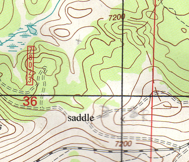
This is my USGS topo. My plan was to walk from the saddle due north, towards the pencil X on the map.
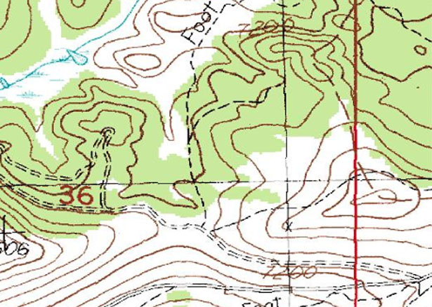
This is the map I could see on my GPS unit. Note the path that went north from the saddle, but not shown on the earlier map.
It turns out that, when I looked at my paper topo map in daylight, the road I thought that they had taken was actually going due east, straight up to the top of the hill east of the saddle. The hunters went straight north, but there was no road or trail. The topo map on my GPS showed a path going north, so I wanted to explore that direction and see if I could hunt the meadows that they had told me about and that I could see on both of my maps.
I hiked to the saddle in ten minutes and arrived with it still quite dark. The "path" that they had taken was actually a road, which I could see in the dim light of the moon. Near the saddle there was a lot of slash from a recent timber harvest. I noted later that the ground was not all torn by the wheels of the harvest machinery as I have seen in California. Disturbing the soil retards reforestation significantly, even permanently if the disturbed soil washes away. Whoever had done the timber harvesting here had done it with a very light footprint. There was no regeneration as yet, as this seems to have been done this season or the previous, but the soil had a lot of grass growing so the soil was safe from erosion, to my eye.
The road here seemed passable by a vehicle for a few hundred yards from the saddle, then became progressively worse. It appeared to be an old logging road that had fallen into disrepair, and further along I found that it had been blocked off by berms and rock piles, which I could barely see in the gathering dawn. I am guessing that the forest service had closed off the road some time ago. The road contoured along the mountain and there was no steep gradient; this is a key consideration, all else being equal, when you think about packing out an animal the size of a horse.
The forest was primarily lodgepole pine (Pinus contorta, since the two needles are twisted) and Engleman spruce, which is a much denser tree, and useful for retreating from the snow, as you shall see later.
I kept pussyfooting down the path, using the binocs every ten feet or so. It makes for very slow progress, but the forest is so thick that it is very hard to see more than 100 feet, and the only chance is to see a part of an elk through the trees before you are right on top of them and they ghost away.
For a while, as daylight began, there seemed to be some kind of clearing parallel to the road and off to my left. It was hard to see into it, and it was only 50 feet wide, with indistinct margins. The trees seemed to fill parts of the clearing, widen out for a bit, then close down again. The margins were not distinct, as the margins of clearings are at the Ranch. Finally I decided that the clearing was a marshy beginning to the larger clearing on my map that was my goal (see map above and the clearing along the early part of the trail). But unlike the map, which showed a distinct clear area of 100 yards or so, the forest was claiming land and it was a lot less open than the map suggested. The challenge I was beginning to understand is that the map can show something as open (white area) or as forested (green area) and nothing in between; reality was much more complex, and it might have changed since the map data was gathered. While this dichotomy is obvious now, I am not sure I had run into this previously with such a difference between the map and the territory.
I kept pussyfooting along, peering into the woods with my binocs. After a bit I saw ahead of me a much larger opening, perhaps one I might be able to hunt, but it was not shown on my map. It extended back to my left, and looked up along the clearing that had been beside the path. I crept up to it, examined every nook and cranny but saw nothing. I crossed the meadow and was able to find a place I could hole up and yet still see along the long axis of the meadow.
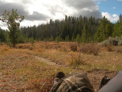
This is looking back up the trail I had been walking, it disappears into the trees to the left;
I was leaning against a lodgepole pine that was back a bit from the margin
I stayed there for about 30 minutes. There were some energetic nutcrackers, playing in twos.
The Clark's Nutcracker (also called Clark's jay) is a grey bird in the Corvus family (crows and jays), named after the Clark of Lewis and Clark. They were flying from tree to tree or from tree to the ground, seemingly just having fun but almost certainly foraging. Existence must be hard for them at 7000 ft., winter or summer.
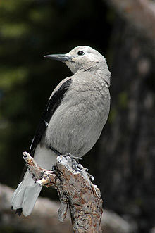
Clark's Nutcracker (from Wikipedia)
I can't imagine that they were finding much besides lodgepole pine seeds. The lodgepole cone is serotinous. While the short meaning of this is that the cones only open when exposed to fire, the actual reality is much more complex, just like the white and green areas on my map. According to a US Forest Service publication, the seed supply is has many variables. Each stand of lodgepole pine has some trees that are not serotinous, so some trees are shedding seeds without fire to release them. In addition, fire is actually not the only way seeds are released: both serotinous and and nonserotinous cones will open when in contact with the soil. Therefore, it turns out that while the majority of cones will open after a fire, assuring a bountiful supply of seeds for the fire-enriched and cleared soil, there are always seeds available, both in cones and on the ground. The Clark's Nutcracker can peck open the serotinous cones or scavenge the seeds on the ground that are not yet destroyed by fungus.
The jays may also have been eating insects. While you might think that the bugs would be entirely missing from the area due to the triple whammy of the elevation (7000 feet), the time of year (October), and the weather (nights hit a low while we were there of about 0 degrees), I saw thousands of bugs take flight in another meadow when the afternoon sun hit the grasses and the temperatures rose from terribly cold to pleasing. So, as Jeffrey Goldblum's character says in Jurassic Park, "Life finds a way."
The clouds moved along and the Clark's Nutcrackers flew, but not much else moved; certainly no elk.
I moved on after about half an hour or so, following the same trail. It was still very early in the morning, with clouds coming and going. I could tell from my map and GPS that there was a larger clearing ahead. The trail, which had been descending steadily since I left the saddle, now started to rise slightly, then descended into a valley with a meadow at the bottom. I kept back in the trees and checked it out, glad to again be able to see more than a few feet. There was nothing in the meadow at all.
All meadows are kept clear of trees by the fact that they are too waterlogged at some point in the season for pines to survive. The variation in rainy vs dry years means that over decades there is a constant yin and yang to the treeline around any meadow. This meadow was rather soggy right now, so I needed to be careful about crossing if I did not want to soak my boots.
The edge of the meadow had been logged, with many stumps along the close border. The meadow was only about 30 yards wide at this place, but the path disappeared in the grass.
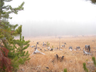
Stumps along the edge of the meadow, with a cloud moving in and obscuring the far side
I marked the place the path entered the meadow with some horizontal logs balanced on the stumps, some oriented N-S and others E-W, so that I could recognize my marks no matter which direction I approached from. There is an important asymmetry that you need to recognize, or you will get in trouble: it is easy to recognize the meadow as you leave the forest, but it can be very hard to recognize the path as you leave the meadow and enter the forest. On your return, every edge of the meadow will look like there might be a path there, and all the paths will tend to become indistinct as they come up to the edge of the forest. The animals disperse as they leave the confines of the forest and enter the openness of the meadow, so the path is not well-defined. This is partly what got Craig in trouble finding his elk when he returned with the guys.
There was a sapling at the edge of the forest which had been thrashed into a simple bare pole, and the grass around it had been churned into dirt, a certain sign that at some point in the past elk had thought of this as a good place to hang around. I found this encouraging.
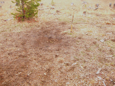
Grass torn apart with a bare pole just to the right, the remains of a sapling
I moved to the edge of the meadow and checked it out. The meadow was shaped roughly like the letter Y, with three arms. The longest two arms were aligned with the creek I had been following, the short arm extended to my right. I crossed the meadow and went into a small peninsula of trees and downed wood at the center of the Y that projected out into the meadow, allowing me a view into all three arms. I made myself a comfortable nest behind a downed log, propped my back against my pack, got out my lunch, water, and shooting sticks, and settle down for a long watch.
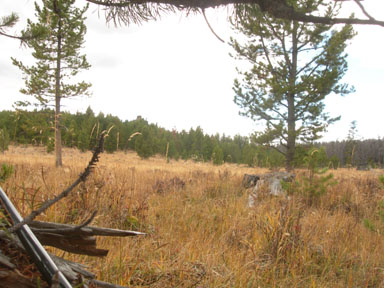
View to the left from my hiding place behind a log;
the path came in at the left side of the photo;
note that there is no clear indication of a path anywhere
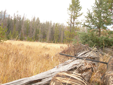
View to my right from my hiding place behind a log
It was somewhere around 10 am. The clouds were mostly high, so I could see well. At times, they would blow in low and hugging the ground, such that I could not see the far margin. I binoc'ed everything, peering into the forest edge for a hock, a white rump, an ear or an eye. Nothing.
I had time to ponder elk hunting in a dense lodgepole pine forest. For most of the morning, I had been in dense forest, with hardly a view to anywhere or anything. This was quite a bit different from the Ranch, where I learned hunting and, in fact, defines hunting to me. I had had to learn a different style of hunting in Wyoming at Five Buttes: wide open sage and less than five trees in more than five square miles. I did not think that there could be any deer there, as there looked like there was not enough ground cover to hide a squirrel. Bill proved me wrong, which is what led to several of the Wyoming Funnies I did (see Cartoon Six, Cartoon Twenty, and particularly Cartoon Eighteen), and I slowly learned how to hunt the sage.
This lodgepole forest was also going to take its own hunting method.
I prefer to hike until I find a particularly promising area, then stake it out. The dense forest seemed to me to not provide much of a chance to see anything: you are so close before you can see anything that the elk will have moved out long before you got close. Even if you see anything, all you see is a hock, a hair, or a hind end. You never see the head (so you determine if the bull is legal) and the chest (so you can get a shot), and in that order! It does not do any good to see the chest and then the head! This was one heck of different kettle of fish. I did not yet know how to handle it, but I was applying what I knew of hunting to it. Check out the map, find a likely area or terrain, get there before dawn, and place your butt where you can see and where you think there might be game.
I was certainly there: the meadow looked very promising. Even if I did not expect to see a bull in the middle of the grass, perhaps one would come to the marge to get a taste change from the shadowed forest grasses. Elk are grazers, not browers, that I knew. I would bet that the meadow grasses were different from the fare the elk grazed on deep in the trees, and tasted different to an elk. All the books and magazines show them grazing on the edges of meadows. All the stories are about catching the elk in a meadow. So now I was nestled down at the center of a Y of meadows, virtually completely hidden by the trees around me and by the log I was lying behind.
I peered into the lodgepoles, I peered into the willows along the creek, I peered around a large boulder that I named Table Rock due to its flat top and rectangular shape. I peered and I peered, then I petered out and went to sleep.
I would open my eyes every now and again. The clouds would move in or move out, as they saw fit. But I saw nothing and closed my eyes.
I was so comfortable, and the meadow was so perfect looking, I dozed and peered and ate and peered, until it was getting toward late afternoon. Then I scrunched myself into a better shooting position, still hidden by the log. Darkness crept into the meadow, and still I peered. This should be the best hunting time. Nothing but darkness crept into the meadow. With just a bit of light, I packed up and got my headlight on, put my GPS and map where they were handy, and headed back. I could see my horizontal markers balanced on the stumps with my binocs, so I headed right to the path and hoofed it back.
It was quite dark when I got to the saddle, but I had done this part in the dark before and it was no problem. Darkness to darkness, a long day, nothing. I drove back to the cabin and the boys.
Back to Wyoming Homepage Back to 2011 Homepage
Back to 2011 Page One: Introduction Back to 2011 Page Two: Opening Day
Back to 2011 Page Three: Craig's Elk Back to 2100 Page Four: Finding Craig's Elk
Back to 2011 Page Six: David's Meadows, Day 3